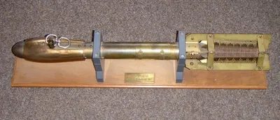
For decades, the understanding of the hidden thermal structure of the sea has been based on a specific class of marine research equipment: the bathythermograph. These devices are essentially pressure and temperature sensors that continuously visually record how the water temperature changes with depth. By combining pressure data with depth, scientists can map the vertical profile of the ocean’s heat content with surprising precision.
The technology can be divided into two different operating models, each of which is suitable for different measurement needs. The classic, returnable version is lowered from a ship. Regardless of whether the vessel is docked or adrift, the instrument sinks through the water column. A coated glass plate inside stores the analog data. When the device is submerged, the pressure-sensitive elements expand or contract, moving the stylus that engraves the temperature and pressure readings on the glass. This physical record provides a detailed, uninterrupted profile of the water layers encountered during descent.
In contrast, the expendable bathythermograph has a different purpose: speed and scale. These units are often deployed from aircraft, dropped into the sea and quickly sink. They leave no physical record. Instead, they send data wirelessly back to the surface via radio signals. This feature allows researchers to collect temperature profiles from depths of up to 300 meters (about 1,000 feet) without having to stop or maneuver the aircraft.
This wireless, single-use method is especially valuable for large-area surveys. Instead of taking time-consuming measurements at specific locations, researchers can drop dozens of these units from a moving aircraft to create a comprehensive heat map of the ocean’s surface. It answers the critical question of where temperature gradients occur across large stretches of ocean, providing information that could not be efficiently collected with slow, recoverable instruments.
Why vertical temperature profiles are important
The data collected by these devices does not only mean how warm the water is at a certain point. It shows ocean stratification. Layers of water with different temperatures and densities interact in complex ways and affect everything from ocean migration patterns to the movements of surface currents.
Returnable bathythermographs provide high-resolution data for local surveys. Glass recording enables very fine-grained analysis of thermoclines—the sharp temperature fluctuations that often mark the boundary between mixed surface waters and deeper, colder layers. This detail is crucial to understanding local ecosystems and acoustic propagation, which affects both marine life and sonar technology.
Expendable types, on the other hand, value quantity over granular detail. By sacrificing physical record for real-time transmission, they enable rapid assessment of large geographic areas. This is important in monitoring phenomena extending over hundreds of kilometers, such as upwelling zones or the spread of warm water eddies. The ability to drop these units from aircraft allows temperature data to be collected quickly and safely even in rough seas or in remote areas where shipping is difficult.
Development of ocean heat measurement
Although modern technology has introduced electronic sensors and digital telemetry, the basic principle of the bathythermograph is still relevant. The difference between recoverable and expendable methods continues to shape ocean researchers’ data collection.
Returnable instruments are still used when detailed post-mission analysis is required. The physical records of the slide can be revisited, creating a permanent ocean archive